Projects
Group of Micrometeorology - IAG/USP
Ipero Project
The Iperó project was funding by FAPESP (Proc. FAPESP No 90/4492-2, "Study of the Planetary Boundary Layer over tropical and subtropical regions: Observations and Modeling”). During the observational phase of this project were performed four intensive field campaigns, between 1991 and 1993, each one lasting two weeks.
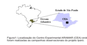
The main objective of this project is to determine the spatial and temporal evolution of the Planetary Boundary Layer (PBL) in the region of Iperó and its impact in the pollutant dispersion conditions on short (< 5 km), medium (5km - 50km) and long range (> 50 km). This information is important for environmental management of areas occupied for nuclear installations as in the case of “Centro Experimental Aramar” (CEA) of the Brazilian Navy, located in Iperó (Figure 1).
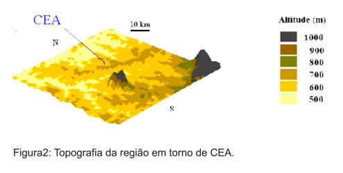
The Iperó region is characterized by a complex topography (Figure 2) and the knowledge of the topographical control on local circulations and PBL structure is necessary to forecast the effects of continuous or accidental emissions in the atmosphere.
Observational Campaigns
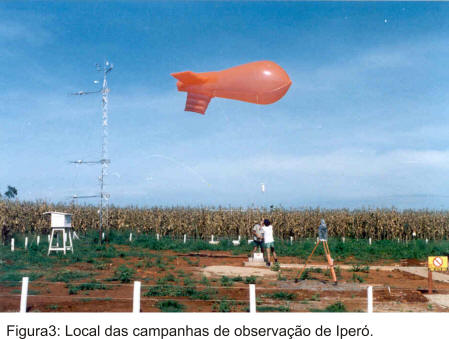
During the observational campaigns were used turbulence sensors as sonic anemometer, krypton hygrometer and fine wire thermometer, coupled to a micrometeorological tower of 12 m.
It was also used sensors of solar and terrestrial radiation to estimate the temporal evolution of the surface radiation balance and sensors of temperature and humidity to determine the thermal properties and content of humidity of the soil. Vertical profiles of temperature, humidity and wind, with high vertical and temporal resolution, determined through tethered balloons and radiosonde, complemented the surface observations (Figure 3).
As result of the project, it was observed that, in general, the PBL of the region varies between 100 and 300 m in the nocturnal period, reaching about 2000 m in the end of the daylight (Oliveira, et al.1998; Oliveira, 2003). It also verified that the PBL wind field presents a cyclical diurnal variation with predominant winds of quadrant NW and NE, during the day, and SW and SE in the nocturnal period. Moreover, it was evidenced the presence of low-level nocturnal jets of the order of 5-10 m/s, predominantly of SE and NE.
Turbulence measurements provided information about the presence of coherent structures for temperature and humidity, which in turn contribute with more than 40 % of the turbulent vertical flows of sensible and latent heat (Krusche, 1997; Krusche and Oliveira, 2004). The spectral properties of the turbulence of this region also had been determined and disclosed characteristics similar to the ones of flat and homogeneous surface, with the spectrum and co-spectrum of wind speed and temperature obeying, respectively, the Laws of -5/3 and -7/3 in the inertial subinterval (Lamesa, 2001).
Numerical modeling of PBL
From the observations were developed some numerical studies with the objective to simulate the evolution of the PBL and its impact in the pollutant dispersion in the region.
Mixed layer model
A numerical model of two layers was developed to simulate the PBL spatial evolution of the PBL and the temporal evolution of the radionuclides concentration in the region of Iperó assuming a hypothetical release of radionuclides (Molnary, 1993).This model, despite the simplifications assumed for the behavior of the PBL, was able to simulate the main characteristics of the PBL evolution in the region and also it allowed determining the horizontal transport of radionuclides and the time that would take to reach the more populated regions, as Sorocaba.
Second order closure model
The temporal evolution of the planetary boundary layer was investigated through a second order closure model connected to a numerical scheme of atmospheric long wave calculation and a scheme of soil-vegetation-atmosphere interaction with comparable results to the observed ones (Vasconcelos, 1995, Oliveira 2003).
Dispersion model SPM
Other attempts to estimate the atmospheric potential of contamination in the region had been made through a numerical model, Skewed Puff Model (SPM), to simulate the hypothetical radionuclides emissions in Iperó, estimating the diffusion parameters using the turbulence data collected during the campaigns (Tirabassi et al., 1995).
The algorithm used to estimate the dispersion parameters, including the effect associates to the presence of the vegetation of the surface (Targino, 1999; Targino and Soares, 2002), had a positive impact in the result quality of the SPM model and allowed to extend the simulations for a longer period of the time (Oliveira et al., 1998).
The research referring to the model of dispersion SPM were developed during an accord of international contribution with the Group of Air Pollution of Institute FISBAT, Bologna, Italy, financed by CNPq (Proc. CNPQ 910132/93 and 910157/95-2), between 1994 and 1997.
Model of mass adjustment
Considering a model that adjust the wind field to the topography by mass conservation, the SPM model and the algorithm developed to estimate the dispersion parameters were applied to evaluate the effect of local topography on the horizontal transport of radionuclide (Veleda, 2001).
Model of mesoscale TVM
Simultaneously, it was investigated the role play the topography on the local circulation in Iperó - diurnal cycle and nocturnal low level jet - using a numerical mesoscale model called TVM. The simulations performed with the TVM indicated that part of the diurnal cycle of the Iperó wind is related to the thermal effect of the topography, that is inclined for west (Figure 2), generating an anabatic wind of SW during the day, and katabatic wind of NE during the night (Karam, 1995; Karam, 2002).
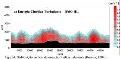
With the not-hydrostatic version of model TVM it was possible to identify that the low level jets in Iperó are resultant of the combination of the thermal circulation generated by the topography and the sea breeze that penetrates inland in the State of São Paulo (Karam, 2002, Pereira, 2004). It was also possible to show that topography and soil landuse in Iperó region have a great impact on the pollutant transport of long (Karam, 2002) and middle range (Pereira et al., 2001; Pereira, 2004).
Model LES
Currently, efforts have been concentrated in the investigation of the thermal convection effects on the atmospheric dispersion on short range (< 5km), using a Large Eddy Simulation model (LES).
These studies have indicated that for the stability conditionsfrequently observed in Iperó, the pollutants emitted for a punctual and continuous source propagate in the vertical direction reaching the top of PBL in less than 10 minutes (Marques Filhos, et al. 2002; Marques Filho, 2004).
Most relevant publications
Oliveira A.P., Soares J., Karam H.A., Pereira M.M.R., Marques Filho E.P., 2004: Numerical modeling of the planetary boundary layer. Revista Brasileira de Engenharia Térmica, 5, 74-83.
Pereira M.M.R., 2004: Estudo do Transporte Local de Poluentes em Iperó por meio de um Modelo Lagrangiano de Partículas. Tese de Doutorado. Departamento de Ciências Atmosféricas. Instituto de Astronomia, Geofísica e Ciências Atmosféricas. Universidade de São Paulo. São Paulo. SP. Brasil. 118 pp.
Marques Filho E.P., 2004: Investigação da CLP convectiva com modelo LES aplicado a dispersão de poluentes. Tese de Doutorado. Departamento de Ciências Atmosféricas. Instituto de Astronomia, Geofísica e Ciências Atmosféricas. Universidade de São Paulo. São Paulo. SP. Brasil.
Krusche N. and Oliveira A.P.,2004: Characterization of Coherent Structures in the Atmospheric Surface Layer, Boundary-Layer Meteorology, 111, 191-211.
Oliveira A.P., 2003: Investigação da Camada Limite Planetária na Região de Iperó. Tese de Livre docência. Departamento de Ciências Atmosféricas. Instituto de Astronomia, Geofísica e Ciências Atmosféricas. Universidade de São Paulo. São Paulo. SP. Brasil. 220 pp.
Marques E.P., Oliveira A.P., Karam H.A. e Rizza U., 2003: Simulação Numérica do Transporte de um Poluente Inerte e Passivo na CLP Convectiva através de um modelo LES. Revista Ciência e Natura, 1, 83-96.
Targino A.C.L. and Soares J., 2002: Modeling surface energy fluxes for Iperó, SP, Brazil: an approach using numerical inversion. Atmospheric Research, Elsevier Science Inc, New York, 63(1), 101-121.
Karam H.A., 2002: Estudo Numérico dos Jatos de Baixos Níveis e suas Implicações na Dispersão de Poluentes no Estado de São Paulo. Tese de Doutorado. Departamento de Ciências Atmosféricas. Instituto de Astronomia, Geofísica e Ciências Atmosféricas. Universidade de São Paulo. São Paulo. SP. Brasil. 196 pp.
Pereira M.M.R., Oliveira A.P. and Karam H.A., 2001: Application of a Lagrangian Model To Investigate Patterns of Radionuclides Dispersion Over Complex Terrain - Part 2: The Impact of Low-Level Jet in the Concentration Field. Proceedings of the Seventh International Conference on Harmonisation within Atmospheric Dispersion Modelling for Regulatory Purposes, 28-31 May 2001, Belgirate, Itália, 400-404.
Lamesa J.E., 2001: Estudo espectral da camada limite superficial de Iperó-SP. Dissertação de Mestrado. Departamento de Ciências Atmosféricas. Instituto de Astronomia, Geofísica e Ciências Atmosféricas. Universidade de São Paulo. São Paulo. SP. Brasil. 93 pp.
Veleda D.R.A., 2001: Ajuste do campo do vento sobre topografia complexa aplicado a um modelo de dispersão de poluentes. Dissertação de Mestrado. Departamento de Ciências Atmosféricas. Instituto de Astronomia, Geofísica e Ciências Atmosféricas. Universidade de São Paulo. São Paulo. SP. Brasil. 79 pp.
Scolar, J., Caetano Neto, E. S., Oliveira, A. P. e Soares, J., 2000: Simulação numérica da camada limite planetária na região de Iperó SP-Brasil. Revista Brasileira de Geofísica, 18 (1), 1-20.
Targino A.C.L., 1999: Modelagem de balanços de energia para Iperó (SP): Uma abordagem utilizando método de inversão. Dissertação de Mestrado. Departamento de Ciências Atmosféricas. Instituto de Astronomia, Geofísica e Ciências Atmosféricas. Universidade de São Paulo. São Paulo. SP. Brasil. 108 pp.
Oliveira A.P., Soares J., Tirabassi T. and Rizza U., 1998: A surface energy-budget model coupled with a Skewed Puff Model for Investigating the Dispersion of radionuclides in a Subtropical area of Brazil. II Nuovo Cimento, 21C, 631-637.
Krusche N., 1997: Estudo das Estruturas Coerentes na Camada Limite Superficial em Iperó - São Paulo. Tese de Doutorado. Departamento de Ciências Atmosféricas. Instituto de Astronomia, Geofísica e Ciências Atmosféricas. Universidade de São Paulo. São Paulo. SP. Brasil. 194 pp.
Tirabassi, T., A.P. Oliveira, M.F. Andrade, O.L.L. Moraes, G.A. Degrazia, 1995: Una Collaborazione di ricerca Italia-Brasile per lo Studio della dispersione di radionuclidi in una regione subtropicale del Brasile. Agrometeorologia Emilia-Romana, 1, 4-6.
Vasconcelos C.M.P., 1995: Estudo Numérico da Camada Limite Estável através de um modelo de fechamento de segunda ordem. Dissertação de Mestrado. Departamento de Ciências Atmosféricas. Instituto de Astronomia, Geofísica e Ciências Atmosféricas. Universidade de São Paulo. São Paulo. SP. Brasil. 93 pp.
Karam H.A., 1995: Simulação Numérica da CLP na região de Iperó através de um modelo de 3 Dimensões. Dissertação de Mestrado. Departamento de Ciências Atmosféricas. Instituto de Astronomia, Geofísica e Ciências Atmosféricas. Universidade de São Paulo. São Paulo. SP. Brasil. 112 pp.
Oliveira A.P., Moraes O.L.L., Degrazia G.A. and Molnary L., 1994: Observational Studies of the Planetary Boundary Layer at Sub-Tropical Regions of Brazil, Revista Brasileira de Geofisica, 12, 55-58.
Molnary L., 1993: Caracterização de um modelo de camada limite planetária para avaliar liberações de radionuclídeos em instalações nucleares. Dissertação de Mestrado. Departamento de Ciências Atmosféricas. Instituto de Astronomia, Geofísica e Ciências Atmosféricas. Universidade de São Paulo. São Paulo. SP. Brasil. 122 pp.